Flood Gauge Mapping System
Targeted property flood information at your fingertips!
This is an important flood education tool and allows you to understand what the flood gauges mean to your property. The Bureau of Meteorology operate the Burnett River Flood Warning System.
It is important that everyone is prepared for future floods so take the time to browse these interactive maps and understand how floods might impact you. You can print an entire booklet of maps relating to your area of interest and animate the rise and fall of the river over some 270 square kilometres of the floodplain!
Historical Flood Maps
You can access the 2013 flood map here.
Or simulate the extent of historical floods by using the Flood Gauge Mapping System and following the below steps:
- Open Flood Gauge Mapping System (button below)
- Choose ‘Select a Flood Gauge’ and next
- Choose ‘Bundaberg (Targo Street)’ and next
- From the drop down menu, select the closest increment based on the table below (for example, to see the January 2013 flood level select 9.5) and select.
Once in the mapping system you can toggle different flood levels to understand your risk and simulate how smaller or bigger floods may impact on you.
You can also see the extent of the 2013 flood by viewing the high resolution imagery. After following the above steps, select the 'Basemaps' icon in the bottom left corner of the map then select the 'BRC Flood' option.
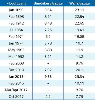
Source: Flood Warning System for the Burnett River (BoM 2021)
Flood level relationships - Paradise Dam to Bundaberg
General relationships of Paradise Dam and Walla Gauge flood levels to Bundaberg Gauge